


By Jade Delevaux
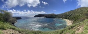
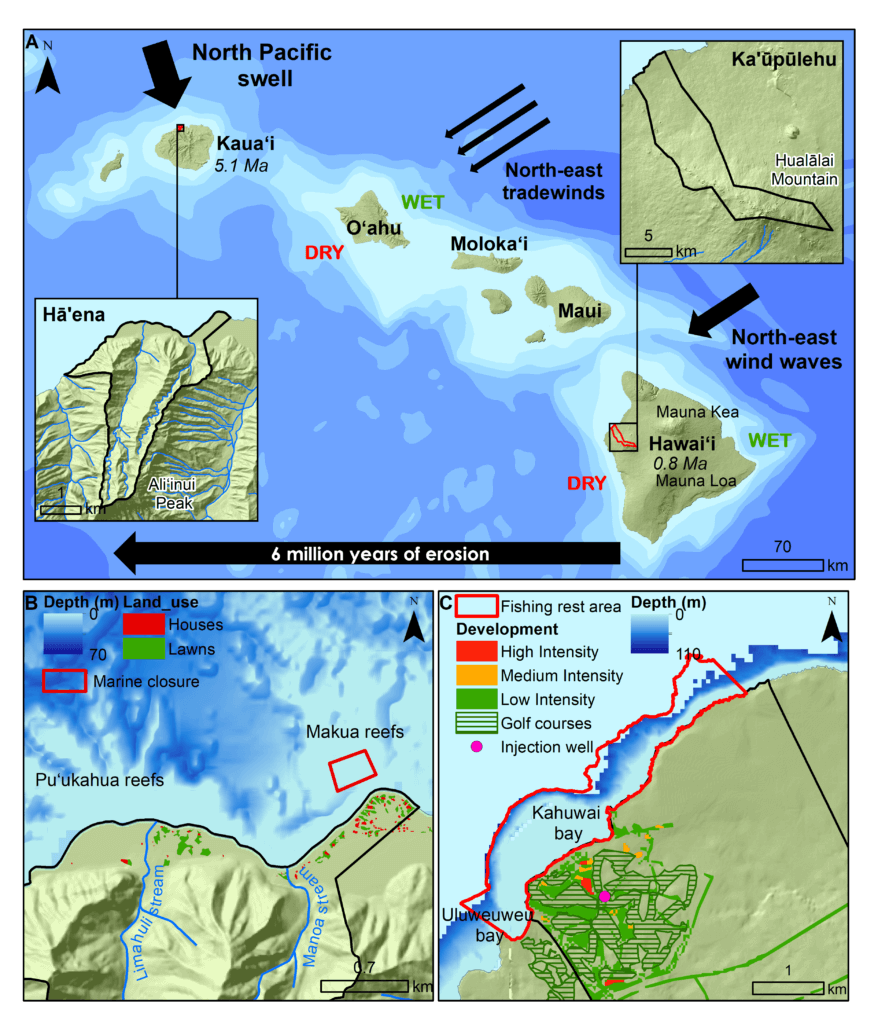
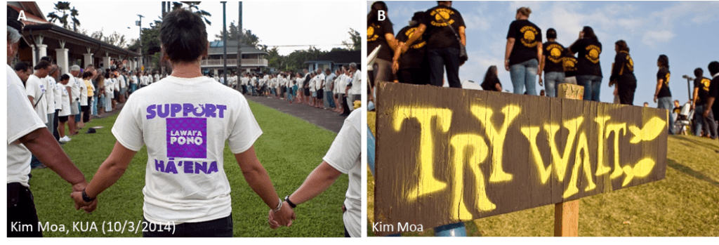
A community member from Haʻēna, located on the windward side of Kauaʻi (see Fig 1A), said “come” as she offered her hand inviting me in. I stepped into the forming circle of the pule (prayer), and we stood together silently listening to an oli chanted by a local kupuna (elder) (see Photo 1A). This moment blessed the opening of a public hearing which eventually led to the passage of rule package of Haʻēna Community Based Subsistence Fisheries Management Area (CBSFA) in mid-2015. The significance of this event cannot be understated. This was the first time in the U.S. state of Hawaiʻi that local-level fisheries management rules based on indigenous Hawaiian practices were recognized. Among these rules, a marine refuge (Makua Pu‘uhonua) was designated in the sheltered lagoon of Makua reef to protect a key fish nursery area (see Fig 1B). That same year, the community of Kaʻūpūlehu, located on the leeward side of Hawaiʻi Island (see Fig 1A), initiated a law implementing a 10-year fishing rest period known as ‘Try Wait’ (see Photo 1B). This resulted in the protection of the entire coral reef fringing reef area (see Fig 1C).
These two communities embody a cultural renaissance that seeks to revive customary management approaches, such as pono fishing practices, kapu (traditional closures), and the ahupua‘a (ridge-to-reef) approach in Hawai‘i to protect terrestrial, freshwater, and marine resources. Both communities initiated these marine closures to protect fish species that feed on algae (herbivorous fish). Without these herbivorous species, algae blooms can cover the reef when excess nutrients flow into the sea from the land. By eating the algae, these protected fish create space for new corals to settle and ensure the persistence or resilience of the reefs. Resilience has been defined as the capacity of an ecosystem to cope with disturbances without shifting to an alternative state, while maintaining its functions and supporting human uses. These local communities are also interested in a better understanding of how land-based sources of pollutants from golf courses, lawns and cesspools affect their marine ecosystems. Even with healthy herbivorous fish populations, these pollutants take a toll on coral reefs, especially with increases in ocean temperature and acidity as a result of climate change. It is important to these communities, and the health of all marine ecosystems, to ensure that future planning takes these impacts into account to promote coral reef resilience to climate change.
Ridge-to-reef management has been widely advocated to foster coral reef resilience, though the degree to which managing land-based pollutants can benefit coral reefs varies among places. In an effort to promote coral reef resilience to climate change, we adopted the traditional ahupua‘a framework to study the effect of existing coastal development on coral reefs and support the restoration of community-based management in Hawai‘i and other Pacific islands. In addition to their engaged communities, we focused on these two locations because they are very different in terms of human coastal development and natural coral reef structure. Hā‘ena is mostly rural with a number of private residences along the coast (see Fig 1B). Kaʻūpūlehu is both commercially and residentially more developed than Hāʻena, with two large luxury resorts, a golf course, and several private residences along the southern end of the coast (see Fig 1C). The powerful waves in Hā‘ena have over time carved wider and shallower reef flats and produced shallow lagoons protected from the swell by well-developed reef crests. In comparison, the coral reefs of Ka‘ūpūlehu are younger and form a relatively narrow fringe on the steep slope of that island.
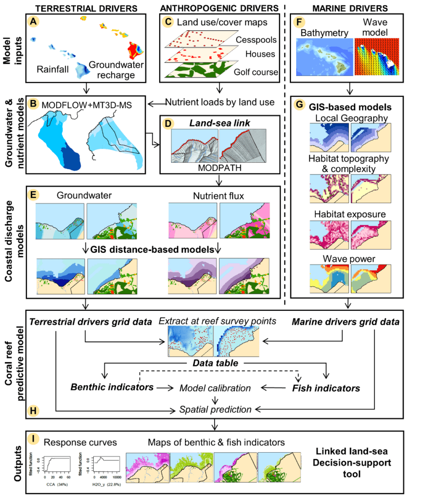
Effective ridge-to-reef management requires improved understanding of land-sea linkages and tools to evaluate the effects of land (e.g. nutrients carried through groundwater) and marine drivers (e.g. wave power and reef topography) on coral reefs. To accomplish this, we developed a framework to link land to sea through groundwater and identify areas on land to manage human-derived nutrients and promote coral reef resilience (see Fig 2). We applied this framework in Hā‘ena and Ka‘ūpūlehu ahupua‘a, to compare outcomes from these different places and inform place-based ridge-to-reef management.
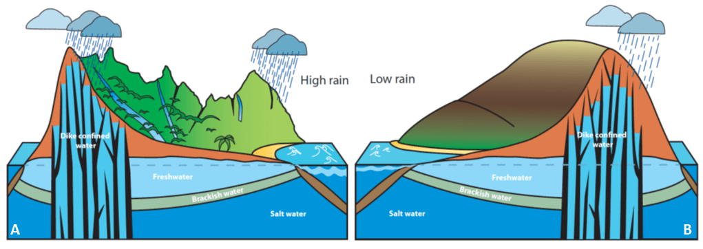
Geologically older and exposed to the trade winds, Hā‘ena receives high rainfall, resulting in steeply eroded cliffs, with high surface and groundwater flow (see Fig 3A). Geologically younger and located in the rain shadows of Mauna Loa and Mauna Kea mountains, Ka‘ūpūlehu is very dry and barely eroded, resulting in low surface flow and high groundwater flow (see Fig 3B). More rain in Hā‘ena means that nutrients are more diluted (less concentrated) than Ka‘ūpūlehu which is much drier. Our groundwater models showed that groundwater in Ka‘ūpūlehu has high levels of nitrogen from natural sources. At Hā‘ena, most nutrients come from natural processes due to abundant rainfall and groundwater flow. The key sources of human-derived nutrients were wastewater from houses on cesspools at Hā‘ena and the golf course and wastewater from the injection well at Kaʻūpūlehu.
To measure the resilience of the coral reefs at each location, we looked at four benthic groups and four fish groups based on their ecological roles and cultural importance to the communities. The benthic groups were crustose coralline algae (CCA), hard corals, turf, and macroalgae. CCA and corals are active reef builders which provide habitat for reef fishes. CCA also stabilize the reef in high-wave environments. Abundant benthic algae can be a sign of high nutrients or low numbers of herbivorous fish, which can harm coral health through competition for space. Algae-eating fish identified as important by the communities (e.g., surgeonfishes and parrotfishes) were modeled based on their feeding modes and ecological role: (1) browsers, (2) grazers, and (3) scrapers.
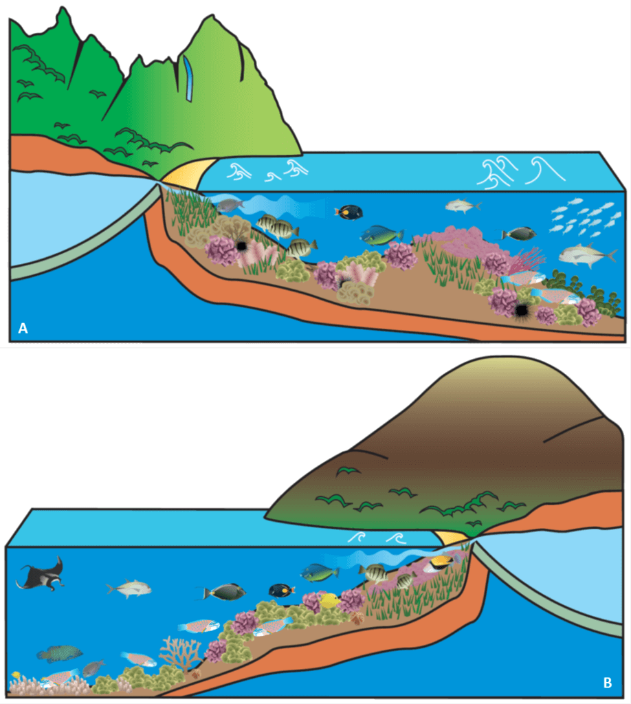
Our coral reef models showed that high wave power at Hā‘ena has shaped the living community of the reefs which are dominated by CCA and turf algae with many grazers and less scrapers (see Fig 4A). Makua lagoon area is an exception where corals are able to grow, sheltered from powerful waves by a well-developed reef crest. In contrast, low wave power in Ka‘ūpūlehu has resulted in coral dominated reefs with high turf and many grazers and scrapers (see Fig 4B). Our coral reef models also showed that land-based nutrients from groundwater can increase benthic algae, suppress coral and CCA, and decrease numbers of locally important fish at both sites.
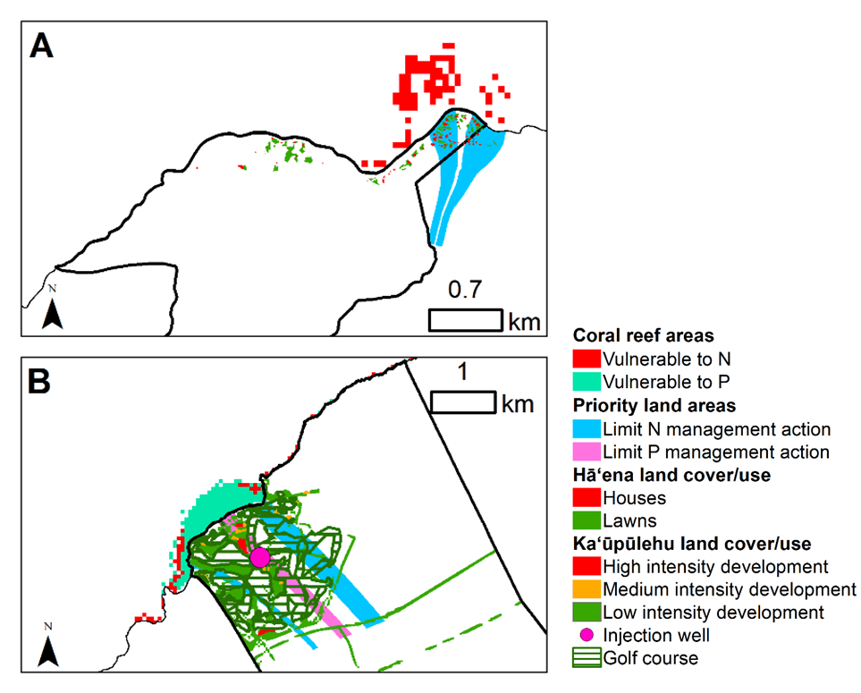
Coral reefs in Hā‘ena seem less susceptible to nutrient inputs from coastal development because they benefit from dilution and mixing, due to high freshwater and wave power. Hā‘ena is rural with limited development or agriculture, so most of the nutrients come from natural processes, with the exception of land areas to the east of the ahupua‘a where nutrients are largely human-derived (see Fig 1B). These areas that contribute high human nutrients lie upstream from the protected reef fish nursery at Makua. We identified this reef as vulnerable to algae blooms and coral bleaching due to the nearness of human-derived nutrient sources, limited mixing from shallow depth and low wave power, and abundant corals and turf algae (marked in red in Fig 5A). To promote coral reef resilience to climate change, Hā‘ena community can focus on upgrading cesspools in the priority areas that we identified, located upstream from Makua (located in blue zone in Fig 5A).
On the other hand, Ka‘ūpūlehu coral reefs seem more vulnerable to nutrient inputs from coastal development due to high levels of background nitrogen in the groundwater and limited dilution and mixing from low rainfall and wave power. Additionally, Ka‘ūpūlehu’s plentiful coral cover is prone to coral bleaching. Based on our findings, the community can focus on not increasing phosphorus inputs from the wastewater injection well (located in the pink zone in Fig 5B) to reduce the vulnerability of coral reefs located downstream (marked in green tea in Fig 5B). In addition, the community can help foster resilience of their coral reefs (marked in red in Fig 5B) by ensuring that environmentally sound practices are continued when fertilizing the golf course, particularly in the land areas located upstream from Uluweuweu bay and Kahuwai bay (located in blue zone in Fig 5B). This will also help to protect the water quality of a culturally important groundwater spring (Wai a Kāne) that was identified by the Ka‘ūpūlehu community in Kahuwai bay (Fig 1C).
This research shows that place matters! Different environmental conditions make place-based solutions essential. Second, protecting herbivorous fish is key for coral growth and recovery. Last but not least, efforts to protect coral reefs need to address nutrient inputs from golf courses and cesspools. Using this framework, we located coral reefs vulnerable to land-based nutrients and linked them to areas on land where limiting sources of human-derived nutrients could prevent increases in benthic algae and promote chances of coral recovery from bleaching. Following on this research, we used this framework to assess the three human factors most relevant to these communities and across Hawai‘i more broadly: coastal development, fishing and climate change. More to come!
Note: This work was funded by the NSF Coastal SEES and formed a chapter of my PhD dissertation at the Department of Natural Resources and Environmental Management (refer to the published article at https://doi.org/10.1371/journal.pone.0193230). The NSF Coastal SEES project Principal Investigators were: Tamara Ticktin (UHM Botany), Kim Burnett (UHERO), Stacy Jupiter (Wildlife Conservation Society, Melanesia), Alan Friedlander (UHM Biology and National Geographic), Tom Giambelluca (UHM Geography), Mehana Vaughan (UHM NREM), Kawika Winter (National Tropical Botanical Garden), Lisa Mandle (Natural Capital Project, Stanford), and Heather McMillen (NREM). Special thanks to the researchers who contributed to this work, in particular Robert Whittier, Kostantinos Stamoulis, Leah Bremer, Natalie Kurashima, and Cheryl Geslani. Many thanks to a collaborating artist, Sophie Eugène, for the illustrations and the Integration and Application Network, University of Maryland Center for Environmental Science (ian.umces.edu/symbols/) for the marine symbols. I would like to also thank Tamara Smith for editing this piece. Finally, we are grateful to our community and landowner partners in Kaʻūpūlehu and Haʻēna who inspired this research and made this project possible.
BLOG POSTS ARE PRELIMINARY MATERIALS CIRCULATED TO STIMULATE DISCUSSION AND CRITICAL COMMENT. THE VIEWS EXPRESSED ARE THOSE OF THE INDIVIDUAL AUTHORS. WHILE BLOG POSTS BENEFIT FROM ACTIVE UHERO DISCUSSION, THEY HAVE NOT UNDERGONE FORMAL ACADEMIC PEER REVIEW.